Меню
Разработки
Разработки  /  Английский язык  /  Уроки  /  8 класс  /  Экспедиции В. Беринга на Камчатку

Экспедиции В. Беринга на Камчатку

Урок английского языка для учащихся 8 класса по теме «Vitus Bering’s Expeditions to Kamchatka». Этнокультурный компонент.
12.09.2021

Содержимое разработки

Background: the first scientific investigation of the eastern part of Russia.

The start of the systematic exploration and scientific discovery in the eastern part of Asia in the 18th century was due to the initiative of Tsar Peter the Great(1672–1725). In 1697 and 1698, he made an exploratory trip through a number of European nations, and became enthused with the idea of founding a scientific academy in Russia. This plan came to fruition in 1723/24 when he decided to draw foreign scholars to Russia and create a scientific academy in St. Petersburg. He hoped to create an extension of the scientific culture of Europe in his own land, and eventually to educate native scholars.

In December 1725, the institution was inaugurated with celebrations. Young, mostly German speaking scholars formed the core of the Academy's personnel in the first decades of its existence. One of their tasks consisted of organising and eventually accompanying scientific expeditions to the then unexplored parts of the Russian empire. During Peter’s lifetime, the German doctor Daniel Gottlieb Messerschmidt (1685–1735) made a journey from 1720 to 1727 to western and central Siberia. This marked the beginning of investigations in the areas of geography, mineralogy, botany, zoology, ethnography, and philology, in this zone, as well as opening up the region to trade and economic development. Messerschmidt's Expedition was the first in a what proved to be series of scientific explorations of Siberia.

Shortly before his death in February 1725, the Tsar signed an order authorizing a second great expedition to the east. Over the course of his life, Peter had met many times with Gottfried Wilhelm Leibniz (1646–1716). At their final meeting at Bad Pyrmont in 1716, Leibniz posed the question as to whether a land bridge existed between northeastern Asia and the North America, a point of great relevance in the contemporary discussion about the origins of humanity, among other matters. It was generally desired that the belief in the common origin of humans not be abandoned, which posed the problem of the origins of human settlements in the New World. In order to resolve the question about the existence of a land bridge between the two continents, Peter the Great sent in 1719 the geodesists Ivan Jevreinow (1694–1724) and Fjodor Luschin (died 1727) to the easternmost reaches of his empire. The expedition was unsuccessful, as least in regard to the land bridge question, and in 1724, Peter gave the same aim to another expedition, the First Kamchatka expedition.


Содержимое разработки

The first Kamchatka expedition (1725-1730)


Peter the Great sent out an expedition led by Vitus Bering. The expedition travelled through Siberia and reached Kamchatka, where a camp was set up and ships were built. On July 13 (24), 1728 Russian Fleet officer, navigator Vitus Jonassen Bering put to sea on the boat “St. Gabriel” in search of the American land. This was the beginning of the first expedition to Kamchatka. Its main objective was to find out if Asia is connected to America or there is a strait between them.

The planning of the Kamchatka Expedition took almost 4 years. Not long before his death in January of 1725 Emperor Peter I wrote with his own hand an instruction to Vitus Bering regarding the expedition. The most popular version in Russian as well as in foreign historiography is that Bering had to go North, in Chukchi Peninsula region, and define whether Asia meets America. Discovering of America was to become the final goal of the navigation; Emperor himself pointed out the necessity of reaching the “city of European possessions”, of “going ashore and drawing up a map”. It was planned to research thoroughly the part of a new land that will be discovered by Russian navigators and maybe even to obtain a certain international certificate of the Russian geographical discoveries.

Bering had manoeuvered in Chukchi Sea for 3 days but due to the maps error the expedition had gone too far north in the strait having left the continent (America) a long way behind. At 4 p.m. August 16 (27), 1728 the boat “St. Gabriel” not having found the unknown land, turned backwards. On its way back the expedition, having passed through the strait, did not see the shores of the modern Alaska either due to the fog. Finally, in summer of 1729 Bering made another effort to discover a land to the East of Kamchatka but strong winds and fog made him again return “empty-handed”.

Reports by Bering and other participants of the expedition, official information on its results in St. Petersburg press of March 16 (27), 1730 and works by many other researchers became legal evidences of geographical version of the first Kamchatka expedition results. In spite of the fact that the expedition had not achieved its main goal Bering had been promoted in rank and received a remuneration. He was also appointed the leader of the new large expedition with another itinerary: to the south-east of Kamchatka.


REPORT OF FLEET-CAPTAIN BERING ON HIS EXPEDITION 
TO THE EASTERN COAST OF SIBERIA.


To the most Serene Sovereign, the high and powerful, the Empress of all the Russia.:
A short relation of the Siberian Expedition upon which (I) was sent. 
Of your Imperial Majesty the most humble servant and fleetcaptain, W.I.Bering.
On February 5 of the late year 1725 I received from her Imperial Majesty the Empress 
Ekaterina Alexievna, of happy and well-deserving memory, the autographic instructions
of his Imperial Mejesty Peter the Great, of happy and well-deserving memory, a copy
of which is hereunto affixed.

Instructions.
(
1.) There should be built on the Kamchatka [River], or at some other place adjacent,
one or two boats with decks.
(
2.) With these boats [you are directed] to sail along the coast which extends northwards 
and which is supposed (since no one knows the end of it) to be continouous with America.
(
3.) And therefore [you are directed] to seek the point where it connects with America and
to go to some settlement uinder European rule, or if any European vessel is seen, learn of it 
what the coast visited is called, which should be taken down in writing, an authentic
account prepared, placed on the chart and brought back here.

From The National Geographic Magazine, Vol. II, No.2, 1890.


Extract from the first expedition:
The vessel was provisioned (in Kamchatka) with everything needful for forty men for a year.
On the 14th day of July we went out of the mouth of the Kamchatka river into the sea, in
 
obedience to the autographic orders given me by his Imperial Mejesty Peter the Great,
as the map constructed for that purpose will show.

August 8th, having arrived in north latitude 64°30', eight men rowed to us from the shore in
a skin-boat, enquiring from whence we came and what was our business there. They said
they were Chuikchi, (Whom the Russians of these parts have long known) and as we lay to
they were urged to come to the vessel. They inflated some floats made of sealskin and sent
 
one man swimming to us to talk, then the boat came up to the vessel and they told us that
on the coast lived many of their nation; that the land not far from there takes a decided turn
to the westward, and they also said that at no great distance from where we were,
 
we should see an island. This proved true, but we saw nothing valuable upon it except huts.

This island in honor of the day we named St.Lawrence (see map below), but we were not
able to see any people upon it, though an officer was sent in a boat from the vessel on
 
two occasions to look for inhabitants.

On the 15th of August we arrived in the latitude of 67°18' and I judged that we had clearly
and fully carried out the instructions given by his Imperial Majesty of glorious and ever
 
deserving memory, because the land no longer extended to the north. Neither from the
Chukchi coast nor to the eastward could any extension of the land be observed.

The expedition returned to Kamchatka, and later arrived back in St. Petersburg on the
 
1st of March, 1730,
 (without having found America).

From The National Geographic Magazine, Vol. II, No.2, 1890.


Содержимое разработки

The second Kamchatka Expedition

The Second Kamchatka Expedition of 1733—1743 led by Captain-Commodore Vitus Bering was one of the most grandiose enterprises in the history of world exploration: it encompassed the whole of Siberia from the Urals to the Pacific coast, the Arctic coast from the North Dvina to Chukotka, coastline areas of the Arctic Ocean and northern part of the Pacific Ocean. The expedition was launched on the initiative of V. Bering and under the auspices of the Russian government: soon after the First Kamchatka Expedition of 1725—1730, the explorer had submitted a proposal to the Admiralty, and an appropriate decree had been issued by Empress Anna on April 14, 1732. Numerous instructions given to the Expedition set the following tasks: a sea voyage to the shore of America; search for a sea route to the Kuril and Japanese Islands; exploration and cartographic survey of coastline regions of North and North-East Siberia; finding out whether there was a gulf between the Asian and American continents; and study of the nature, history and peoples inhabiting Siberia. Coping with these tasks was of both academic and political importance; therefore, information about the Expedition, its progress and results was secret. The detachments counted over 500 scientists, officers, sailors, soldiers, geodesists and other members.

Upon reaching Okhotsk in 1735, Bering had local craftsmen Makar Rogachev and Andrey Kozmin to build two vessels, the St. Peter and the St. Paul. Each ship had 14 cannons and was designed to carry 76 men. Bering's team spent three years building ships and the entire port city that sprang up because of it. That same year Ivan Yelagin was sent by Bering to the east coast of Kamchatka to build a base with houses and supply depots at the Avacha Bay, later named Petropavlovsk, in honor of the two ships.

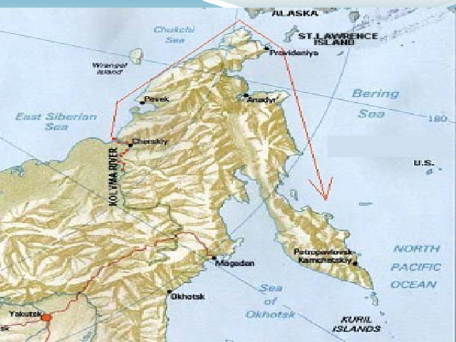
From there he led an expedition towards America in 1741. On 4 June 1741 Bering sailed from Kamchatka aboard the St. Peter with Lieutenant Aleksey Chirikov commanding the St. Paul. First the two captains headed southeast in search of the mythical da Gama Land, which was a prominent feature on an earlier map. Unfortunately, by the time Bering had altered his direction to the northeast, they had sailed hundreds of miles south while missing the entire Aleutian chain.

Meanwhile, on 20 June the two vessels lost each other in heavy fog and were separated. On 15 July 1741 Chirikov sighted the western coast of Prince of Wales Island. Chirikov sent men ashore, but they were never seen again. On 26 July Chirikov wrote that he and his men spotted "some very high mountains, their summits covered in snow, their lower slopes, we thought, covered in trees. This we thought must be America." Chirikov made it to what is now Sitka harbor and was able to sight natives in that area. But unable to go ashore Chirikov decided to return to Russia, unaware of the fate of Bering and his ship, and reached Petropavlovsk in October.

After the separation Bering reached an island in the Alexander Archipelago, probably Prince of Wales Island, near Alaska's southeast coast. A naturalist and physician of German origin named Georg Wilhelm Steller, was recorded as the first European to step on Alaskan soil. As he later complained, it took him ten years to get to this new continent and he was only given ten hours to study it, as Bering was hurrying north while mapping the coastline. Anxious to get the ship back to safety, Bering was able to explore only the southwestern coast of Alaska Bay, the Alaskan Peninsula, and the Aleutian Islands. Catching sight of a volcanic peak, he named it Mount St. Elias, the name it still bears today. One of the sailors died and was buried on an island that was later named after him (Shumagin Island). With supplies running low, Bering decided on 10 August not to spend the winter in America, but to head back west.

Blown off course by fierce winter storms and with a crew so seriously afflicted by scurvy that only three men were able to work on deck, the St. Peter finally sailed within sight of land on 4 November 1741. With their sails and rigging already splitting apart from repeated storms, the exhausted crew so wanted this to be Kamchatka that many thought that they spotted the landmarks of the peninsula from which they had sailed over a year before. The ship was hurled up on the only stretch of beach along a coastline otherwise dominated by rocky cliffs.

Steller was sent ashore to gather plants that could be used to combat the scurvy. He soon deduced that the land they were anchored off was not Kamchatka as the local animals had no fear of man, indicating they must have never seen them before. Steller returned to the ship and quietly told his dying and bedridden captain what he suspected. This could not be Kamchatka and they must have blundered across an undiscovered island. Bering, not wishing to disappoint his men, took the news calmly and said simply, "It's too late to save our ship. God save the longboat!"

The crew spent the winter on the island, living in driftwood huts that were dug into the sand. Thirty men died from scurvy and starvation on the island. Among them was the expedition leader, who died on 19 December.

The only surviving carpenter on the ship, Savva Starodubtsev, with the help of the crew managed to build a smaller vessel out of the wreckage. The new vessel had a keel length of only 12.2 meters (40 feet) and was also named St. Peter. It remained in service for 12 years, sailing between Kamchatka and Okhotsk until 1755. Starodubtsev returned home with governmental awards and later built several other seaworthy ships.

On 14 August 1742, the surviving crew set sail from the shores of what would later be called Bering Island and headed to Kamchatka. On 26 August 1742 they landed in Petropavlovsk, more than two years after they had set out on their voyage of discovery. Out of the 77 men aboard the St. Peter, only 46 survived the hardships of the expedition, which claimed its last victim just one day before arriving at the home port. They spent the winter in Petropavlovsk and arrived in Okhotsk the next year, much to the surprise of the local residents, who had given up hope of seeing the expedition again, and had sold off the belongings of the expedition members.


Over 250 years ago, in November–December of 1741, dramatic events unfolded on a tiny
remote island in the storm-filled waters between Alaska and Siberia. Two Russian ships,
the St. Peter and the St. Paul, sailing as part of the great Russian polar expedition of 1724–1743,
were given the task of charting waters around the Alaska Peninsula and the Aleutian Islands.

Because the ships’ crews suffered from scurvy, the ship’s doctor and naturalist aboard the
St. Peter – a German by the name of Georg Wilhelm Steller – went ashore along the southern
Alaskan coastline to gather plants that could be used to combat the disease. But because
few crewmembers followed Steller’s instructions, the men were continually plagued by illness.

Sailing once again, the ships were battered by storms over a period of several months.
At last the St. Peter anchored on the east side of a small unpopulated island in the Commander
Islands. There, in November of 1741, the ship was hurled up on the only stretch of beach
 
along a coastline otherwise dominated by rocky cliffs. The crew dug crude holes in the ground
for shelter, and lived off of sea otters, seals, and stranded whales. Thirty-one of the ship’s 77
men–weakened by fatigue and plagued by scurvy–finally succumbed to disease and starvation.
Among them was the Danish expedition leader, Vitus Bering, who died on 19 December.
 
Today, that small island bears his name–Ostrov Beringa.
 
From "Vitus Bering. A renowned Danish polar explorer", Danish Arctic Institute


Содержимое разработки

Урок английского языка по теме «Vitus Bering’s Expeditions to Kamchatka»

8 класс

Этнокультурный компонент.

Цель: совершенствование коммуникативной компетенции учащихся в рамках темы «Vitus Berings Expeditions to Kamchatka».

Задачи урока:

Образовательные: практиковать учащихся в чтении, аудировании текстов этнокультурного характера с целью извлечения необходимой информации с последующим использованием её в устной речи; формирование мотивации учащихся к изучению английского языка через этнокультурный компонент; расширение знаний о малой родине в области истории и географии.

Развивающие: развивать умения учащихся читать аутентичный текст с полным пониманием содержания; развивать умения учащихся воспринимать иноязычный текст как источник информации; развивать логику высказывания по теме на основе прочитанного текста; развивать умения систематизировать свои знания, высказывать и обосновывать свою точку зрения; способствовать повышению познавательного интереса к изучению истории родного края; развивать внимание, языковую догадку, слуховую и зрительную память, внимание, способность сопоставлять новое и ранее изученное; активизировать творческую и мыслительную деятельность учащихся.

Воспитательные: формировать у учащихся уважение к истории родного края; учить работать в группах, оценивать работу других учащихся; воспитывать толерантность.

Тип урока: комбинированный.

Образовательные технологии:

- личностно-ориентированного обучения;

- информационно-коммуникативные;

- развития критического мышления;

- элементы технологии АМО;

- здоровьесбережения;

- педагогика сотрудничества.

Наглядность и ТСО: видеозапись «Vitus Bering», презентация «Vitus Berings Expeditions to Kamchatka», ПК, интерактивная доска, проектор.

План урока:

Начало урока:

  1. Организационный момент.

  2. Речевая разминка («мозговой штурм»). - Презентация «Vitus Berings Expeditions to Kamchatka», 1-5 слайды.

  3. Определение темы и цели урока с использованием видеофрагмента.

  4. Постановка проблемного вопроса: Both of the expeditions were made to America in order to find the straight between America and Asia. Why were they called the Kamchatka expeditions?

  5. Определение ожиданий и опасений урока.

Основная часть урока:

  1. Работа с текстами в группах. Заполнение таблиц.

  2. Физкультминутка.

  3. Активизация лексического материала по теме «Vitus Berings Expeditions to Kamchatka».

  4. Решение проблемного вопроса.

Окончание урока:

  1. Возврат к ожиданиям и опасениям.

  2. Предъявление домашнего задания и комментарии по его выполнению.

  3. Подведение итогов. Оценивание работы учащихся.

  4. Рефлексия.


Ход урока:

Этап урока

Время


Содержание урока

Деятельность учителя

1

Организационный момент


1

T.: Good morning students! Glad to see you today! How are you doing? Don’t forget to say “Hello” to our guests. They’ve come here to make sure you’re the most brilliant students.

Sit down, please. Let’s start.

2

Речевая разминка («мозговой штурм»). Презентация «Vitus Berings Expeditions to Kamchatka», 1-5

слайды.

6

T.: Before the lesson started, everybody had been given a card with a word written on it. Read your words, please. Now walk around the class, read the other students’ words, try to group them and make up 4 teams.

Учащиеся группируют предложенные слова по частям речи, формируя 4 команды.

T.: Now let’s check up that everything has been done correctly. Look at the screen (slide 1). Check yourselves. См. Приложение № 1 Презентация «Vitus Bering’s Expeditions to Kamchatka»,

Если команды сформированы некорректно, у учащихся есть возможность найти свою команду.

T.: Who can explain why we’ve grouped the words in such a way?

S.: Parts of speech.

T.: Do you know the meaning of the words? Look at the screen again and try to match the word to its description. (см. Приложение 1 – презентация «Vitus Berings Expeditions to Kamchatka», 1-5

слайды).

Учащиеся высказывают свои предположения, используя в ответах фразы-клише (I suppose, I guess, etc.), затем получают список новых слов с толкованием, которые будут использованы в дальнейшей работе. – См. Приложение № 5.

3

Определение темы и цели урока с использованием видеофрагмента.


4

T.: Look at the words once again. Can you define the topic of our lesson?

S.: no, we can’t.

T.: You are going to watch a video. Be ready with the ideas after the watching.

Учащиеся смотрят видеофрагмент о Витусе Беринге. Высказывают свое мнение о теме урока – Витус Беринг и Камчатка. См. Приложение № 2 – видеофрагмент о Витусе Беринге.

Внимание учащихся акцентируется на словах, записанных на доске. Используя слова, формулируется тема урока – Vitus Berings Expeditions to Kamchatka.

T .: The word “expeditions” is written in plural. Why? How many expeditions were made to Kamchatka? What was the purpose of the expeditions?

В помощь учащимся карта на слайде. См. Приложение 1 - презентация «Vitus Bering’s Expeditions to Kamchatka».


S.: To find the strait between America and Asia .


4

Постановка проблемного вопроса.

1

T.: Both of the expeditions were made to America in order to find the straight between America and Asia. Why were they called the Kamchatka expeditions?

T.: To answer the question you will have to make a voyage to America via Kamchatka. You will visit several ports on your ships. (На столах картинки кораблей) - См. Приложение № 3

5

Определение ожиданий и опасений урока.


3

T.: During your voyage you can meet peaceful and pirate ships. What do you expect from your voyage? What are you afraid of?

T.: Take the stickers, write down your expectations and fears, stick them to the ships.

(На стенах два корабля – пакетбот и пиратский, учащиеся пишут свои ожидания от урока и возможные опасения, помещают стикеры на изображения кораблей).


6

Работа с текстами в группах. Заполнение таблиц.

12

T.: It’s high time to start our voyage. You have got some texts on the desks. Study them carefully and do the tasks. См. Приложение № 4.

(Учащиеся работают в группах. У каждой группы свой текст, лист формата А3 и маркеры. Через три минуты каждая группа перемещается за другой рабочий стол и выполняет другое задание, через три минуты команды снова перемещаются по кругу. При выполнении данного задания использован активный метод обучения «Автобусная остановка». Через 12 минут учащиеся оказываются на своих прежних местах, откуда они начинали свое путешествие. )

7

Физкультминутка.


1

T: It was a hard journey. I suppose, you are tired. Close your eyes. You are lying under the cedar trees. You open your eyes and see the cones. You want to take them. Try to take them. You can’t. Stand up. Try again. You can’t. Jump up high and try once more. That’s a pity, you failed. Try another time.

T.: Now let’s go back to your tasks.

8

Активизация лексического материала по теме «Vitus Berings Expeditions to Kamchatka».

9

Учащиеся выступают, используя подготовленный на уроке материал, по следующим вопросам:

- Background: the first scientific investigation of the eastern part of Russia.

- The first Kamchatka expedition.

- The Second Kamchatka Expedition.

- Who was the first one to find the seaway between Alaska and Asia?

9

Решение проблемного вопроса.

1

T.: Both of the expeditions were made to America in order to find the straight between America and Asia. Why were they called the Kamchatka expeditions?

S.: Because Kamchatka played a great strategic role during the expeditions.

10

Возврат к ожиданиям и опасениям.

1

T.: Remember your expectations and fears. Have you come up to your expectations? Were your fears reasonable?


11

Предъявление домашнего задания и комментарии по его выполнению.

2

T.: Have you got any questions on the lesson?

S.: No.

T.: I have. Semen Dezhnev was the first one to find the strait between America and Asia but it was called THE BERING STRAIT. Why? Your home task is to find any information to answer the question.


12

Подведение итогов. Оценивание работы учащихся.

2

T.: Let’s remember the topic of our lesson today. What was it about? What have (not) you done today?

Good job, thank you, students. I hope you liked the lesson. I liked your job too. You were brilliant. Your marks for the lesson are …

13

Рефлексия. Элементы технологии АМО.

2

T.: Look at the screen. You see a hand. Use the incomplete sentences near each finger to express your attitude to the lesson.

(Учащиеся выражают свое мнение о прошедшем уроке, используя начальные фразы:

- I have learnt…

- It was interesting for me to …

- Now I can …

- It is useful for me to …

- I didn’t like … )

T.: The lesson is over. Good bye. Have a nice day.


3


Содержимое разработки

Who was the first one to find the seaway between Alaska and Asia?

On 30th of June, 1648 expedition of 90 people went out to see from the Kolyma on 7 ships and turned to the East. During their long trip a few of the vessels suffered shipwreck. Semyon Dezhnev successfully finished his distance and has become the first man who managed to get out into the Pacific Ocean from the Arctic Ocean in the whole history. He discovered the Bering Strait and proved Asia is not connected with the American continent.

The expedition lost their ships due to the storms in the sea, which happened one after another. In September, 1648 only 3 of them made it to Chukotski Cape, what later was renamed (at present time it’s mapped as Cape Dezhnev). In the strait the sailors found 2 small islands. Only in 80 years an outstanding sailor Vitus Bering would reach the strait, what consequently was named after his name. The small islands would get the names Big Diomede Island (the Western one) and Little Diomede (the Eastern one). However, in XIX century the Western island would obtain the name after Ratmonov (in honor of the organizer of the first Russian cruise round the world). A map of Russia clearly demonstrates that now between these islands there is the state border between Russian and America.

Dezhnev crossed all the Bering Strait, dividing Chukotka from Alaska, from north to south whereas Vitus Bering sailed only in the Southern part.

Semyon Dezhnev was a Kazak chieftain, Russian sailor and pathfinder, an investigator of the Eastern and Northern Siberia, born approximately in 1605. At first he served as a common Kazak in Tobolsk. For the period of 1636-1646 he disarmed the Yakuts. In 1641 Semyon Dezhnev switched to Yakut pit with its untouched alien tribes. In 1639-1640 he conquered indigenous duke Sahei. Maps of the Anadyr river-banks and maps of a part of the Anyuy are also Semyon Dezhnev’s achievement. Later on, in 1659-1668, Dezhnev carried out expeditions in lower courses of the rivers Lena, Olenyok, Vilyuy.

From 1664 up to 1665 Dezhnev managed to be in Moscow, where his work was highly rewarded. He was assigned to a rank of chieftain. The contribution of this remarkable investigator in development of cartography can hardly be underestimated. Not only important discoveries and maps came up in the world thanks for him but also interesting descriptions of the investigations in the most north-east point were created by him.

Such a figure as that common Russian man, who was distinguished by such a virile character and has made significant geographical discoveries, is kept in the history with care. On the 250th anniversary date of Semyon Dezhnev’s expeditions according to the Tsar’s order the Eastern cape was renamed by the Bering Cape.

If one has a map of Siberia, he will definitely find the Bering Sea bay, a village near the Amur, a chain of mountains and the cape of Chukots Peninsula, named after Semyon Ivanovich Dezhnev.


Содержимое разработки


Содержимое разработки

A strait - a narrow passage of water connecting two seas

A remuneration - a reward for work (e.g. money)

An itinerary - a plan of a journey

An investigation - a careful examination of smth

Fruition - an achievement of what was wanted

To research - to make a detailed study of smth

To manoeuvre - to do clever movements

To launch - to begin

Grandiose - planned on an impressive scale

Numerous - very large in number

Scientific - connected with science

Thoroughly - made in a detailed way

Unsuccessfully - without any success (any achievement)

Consequently - in the result of smth (that’s why)


Содержимое разработки

A strait A remuneration An itinerary 1. Grandiose Thoroughly Unsuccessfully Consequently 2. Numerous To research To manoeuvre To launch
  • A strait
  • A remuneration
  • An itinerary

1. Grandiose

  • Thoroughly
  • Unsuccessfully
  • Consequently

2. Numerous

  • To research
  • To manoeuvre
  • To launch

3. Scientific

A strait A reward for work (e.g. money) A remuneration An achievement of what was wanted An itinerary A careful examination of smth An investigation An narrow passage of water connecting two seas Fruition A plan of a journey

A strait

A reward for work (e.g. money)

A remuneration

An achievement of what was wanted

An itinerary

A careful examination of smth

An investigation

An narrow passage of water connecting two seas

Fruition

A plan of a journey

To research To begin To manoeuvre To make a detailed study of smth To launch To do clever movements

To research

To begin

To manoeuvre

To make a detailed study of smth

To launch

To do clever movements

Grandiose Very large in number Numerous Planned on an impressive scale Scientific Connected with science

Grandiose

Very large in number

Numerous

Planned on an impressive scale

Scientific

Connected with science

Thoroughly Without any success (any achievement) Unsuccessfully In the result of smth (that’s why) Consequently Made in a detailed way

Thoroughly

Without any success (any achievement)

Unsuccessfully

In the result of smth (that’s why)

Consequently

Made in a detailed way

VITUS BERING’S EXPEDITIONS TO KAMCHATKA “ One or two boats with decks should be sent to Kamchatka or another such place”. Instructions given by Peter I to Vitus Bering (1725)

VITUS BERING’S EXPEDITIONS TO KAMCHATKA

“ One or two boats with decks should be

sent to Kamchatka or another such place”.

Instructions given by Peter I to Vitus Bering (1725)

The both expeditions were made to America. Why were they called the Kamchatka expeditions not the American ones?

The both expeditions were made to America. Why were they called the Kamchatka expeditions not the American ones?

Semyon Dezhnev was the first one to find the strait between America and Asia but it was called the Bering Strait. Why?

Semyon Dezhnev was the first one to find the strait between America and Asia but it was called the Bering Strait. Why?

Now I can … … It is useful for me to … It was interesting for me to … I didn’t like … I have learnt …

Now I can … …

It is useful for me to …

It was interesting for me to …

I didn’t like …

I have learnt …

-75%
Курсы повышения квалификации

Современные педагогические технологии в образовательном процессе

Продолжительность 72 часа
Документ: Удостоверение о повышении квалификации
4000 руб.
1000 руб.
Подробнее
Скачать разработку
Сохранить у себя:
Экспедиции В. Беринга на Камчатку (5.33 MB)

Комментарии 0

Чтобы добавить комментарий зарегистрируйтесь или на сайт